Planting Weather Forecast: More Moisture Will Prolong Dryness Over the Next Ten Days


Plenty of precipitation over the state of Michigan in the next 10 days. We will struggle to see big enough drying windows in the state to accomplish much of any planting. Additionally, the amount of moisture coming our way is significant over the next 10 days, so we likely end the period wetter than we are right now.
Rain moved into southern lower MI yesterday, and we will continue to see showers through most of the state through the day today. We likely see action break up a bit late. But this first round of moisture will total .25”-1” with coverage at 90% of the state. After a bit of a dry slot to start Sunday, rains are back later in the day and through Monday. Lingering action in the Thumb can be seen early Tuesday morning to midday. The second round of activity will yield another .25”-1” with coverage at 100% of the state. After a dry Tuesday, a minor front can bring .1”-.5” of scattered shower action Wednesday, along with colder air into the state. It will be a very active pattern.
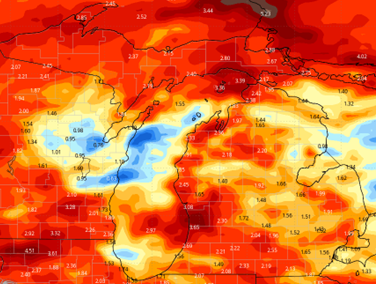
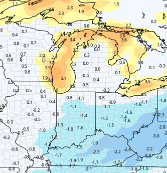
Dry weather emerges for Thursday, Friday and Saturday. Thursday starts cool on the heels of the chilly air late Wednesday. However, we should not be as cold as this past week. Then temps moderate quickly to finish the week, and temps should be near normal. Evaporation rates will be good, near maximum, but we likely just run out of time for drying. Showers are back with a frontal boundary for Sunday the 5th. Rain potential right now looks to be a few tenths to perhaps half an inch, but spotty coverage. That front will be key to seeing a longer term dry window emerging, because those rain totals next weekend are not over the top, it just means we are not drying very much next weekend. The map below shows rain totals for the next 10 days.
Extended Period:
We start the following week dry on Monday the 6th. We keep the dry pattern through the 7th and 8th before a frontal boundary sags through the state for the afternoon of the 9th and early the 10th. Rain totals are not that impressive at a few hundredths to .3” with coverage at 60%. Dry, warm weather is back for the afternoon of the 10th, the 11th and 12th. So, that means in our extended window, we are starting to see some potential planting windows emerge, especially if the system late on the 9th can fizzle out and merely produce sprinkles or hit and miss coverage.
Weeks 3 & 4:
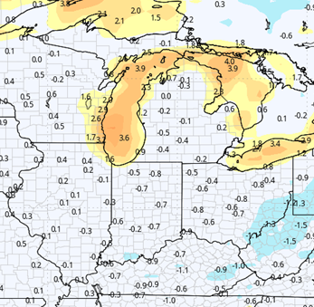
Precipitation looks to be below normal in week 3 and near normal for week 4. If that holds, any planting window that opens in the extended 11-16 day forecast window would be on track to hold into mid-May. Temps though will be below normal in week 3, returning to near normal in week 4.
Week 3 Precipitation (Green = above normal, Brown = below)
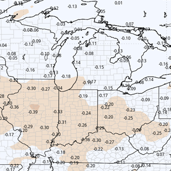
Week 3 Temperatures (yellow/orange = above normal, blue = below)
Week 4 Precipitation (Green = above normal, Brown = below)
Week 4 Temperatures (yellow/orange = above normal, blue = below)